Story & Photos By Bob Shelton
Here is a road trip that nearly everyone who rides can enjoy, and chances are most people have never been here—or even heard of this site.
East Texas has some of the most enjoyable scenery in the state, and I am blessed to live in the middle of it all. U.S. Highway 80, one of the first transcontinental routes across this nation, provides some wonderful riding. But on a recent ride, I left White Oak and traveled south on Texas Highway 42 to Interstate 20, where I turned east. I usually avoid the interstates, but taking this route keeps me from the endless strings of traffic lights in Longview and Marshall. After passing the Marshall exit, I found FM 31 and turned south toward Elysian Fields. The best part of the ride has now begun—these rural roads provide some beautiful scenery year-round.
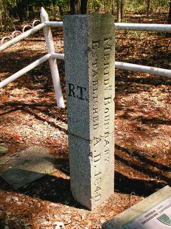
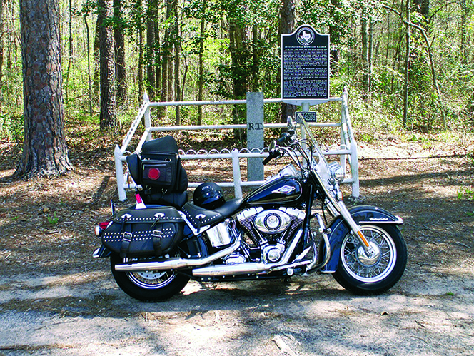
Deadwood, Texas, is one community along the way whose name always brings a smile to my face. (I am reminded of the escapades of people like Wild Bill Hickok and Calamity Jane, who inhabited the untamed City of Deadwood, South Dakota!) By now, I am a couple of hours into my day trip, and after I pass through Galloway, I begin looking for my first stop. On FM 31, between Deadwood and Logansport, Louisiana—on the left—is a unique historical marker that is known to locals but few others. This granite shaft set into the ground on April 23, 1841, marks the only known international boundary marker in the continental United States.
There it is, sitting slightly off the pavement, with a white fence around it and identified by a historical plaque. The marker established the boundary between Texas and Louisiana, but there was a time when the border was contested by France, Spain, the United States, and the Republic of Texas.
When I mention this marker to others, they usually look at me oddly and respond, “What?”

Allow me to explain: When Texas won its independence there was a land dispute between the United States and the new republic. No one really knew where the exact boundaries were along much of the Louisiana Purchase. The eastern boundaries of new Louisiana didn’t really matter, because much of that land already belonged to the United States, but in time, the western boundary of that territory was bordered by the Republic of Texas. It was decided that someone must establish and mark that boundary, and a team of surveyors set out to do just that. The small crew began at the Gulf Coast, where the river met the ocean, and they traveled northward along the Sabine River, plotting the dividing line between the two territories.
At the 32nd parallel it was agreed that the boundary would continue due north and no longer follow the winding path of the ever-twisting and -turning river. Deep in the piney woods, a large granite marker was set in place, establishing the property line between the Republic of Texas and the United States. Today that marker is the only monument of its kind known to exist. One side of it is marked “R.T.,” for “Republic of Texas,” and the other is marked “U.S.” Of course, simply walking around that old granite monument shifts me from one state to the other and back again or, back then, one country to another!
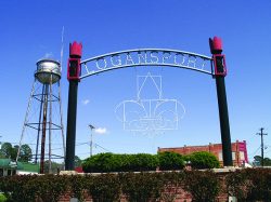
After enjoying the scenery for a while and soaking up some of this little-known Texas history, I am back on two wheels again, and I head into the state of Louisiana. Riding along the eastern side of the Sabine River for about two miles, I enter the town of Logansport. After turning west onto U.S. 84, I see Big Zach’s Place (223 Main St., Logansport; 318-697-5360). One of the best pit stops in the area, this little eatery dishes out a variety of good food, such as crawfish and boiled shrimp, burgers, fried catfish, fresh-brewed coffee, and more. And the service is usually excellent. Logansport is a quaint little town, only a stone’s throw from Texas. A block past Big Zach’s is the Sabine River, which—here, now—is the dividing line between two states, but once was the boundary between two different countries!

A few miles west of Joaquin, Texas, is FM 699, where a traveler will find one of the most scenic routes, heading north, into Carthage. Along that stretch of roadway, the senses are easily employed. For the eyes, there are rolling hills and lowlands, and a variety of well-tended farms and ranches and livestock. For the nose, there are odors of fresh-plowed earth and flowering plants, a hint of cow manure, and the occasional smell of a distant chicken coop. This is good stuff and makes for a great ride.
At the Carthage town square, I turn north onto U.S. Highway 59 and then northwest onto Texas Highway 49. Before long, I find myself sitting at the only traffic light in the little town of Tatum, and down the road I pass over some of the lower portions of pretty Lake Cherokee. The increasing traffic reminds me that I am approaching my home in Longview once again. A short jaunt westward on Interstate 20 will put me on Texas Highway 42 and then home.
The ride is about 165 miles long. My costs were the price of a few gallons of gasoline, plus a good hamburger with trimmings. But the rewards of the ride cannot be measured. Life is good.


